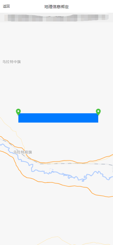
1.需求:后台请求经纬度数据,移动端根据经纬度标点,绘制线路图
2.效果图:
3.页面源码(注释是之后加上去的,直接拿下来可能报错,删除就好了)
<template>
    <view>
         <uni-nav-bar title="地理信息绑定" leftText="返回" @clickLeft="pageHome()" />
        <view class="container">
         		<map :latitude="latitude" :polyline="polyline" :longitude="longitude"   :markers="covers" :show-location="true">
                </map>

        </view>

    </view>
</template>
<script>
      import { userLists,getMemBer ,addUser,delUser,updateUser,getUser,userListAll} from "@/api/system/user.js" //向后台发起请求api
    export default {
        data() {
            return {
                title: 'map',
                latitude: 41.058231, //中心点经纬度
                longitude: 107.596656, //中心点经纬度
                covers: [], //标点经纬度数组,
                users:[],
                deptName:'',
                deptId:"",
                userParam:{
                       userName:this.$store.state.user.name, //若依移动端取用户名的当时
                },
                polyline:[ //连线的属性
                        { //路线
                            points: [], //经纬度数组
                            color: '#007aff', //线的颜色
                            width: 30, //线的宽度
                            borderWidth: 2, //线的厚度
                            // borderColor: '#ff0000', //线的边框颜色
                            dottedLine: false, //是否虚线
                            arrowLine: false //带箭头的线 开发者工具暂不支持该属性
                        },
                ],
                _mapContext:{},


                form:{}
            }
        },
        onLoad(e) {
                  this.deptId = e.deptId;   //页面传值部门id
                  this.deptName = e.deptName;  //页面传值部门名称
                  this.getUserByDept( e.deptId); //通过部门名称查询用户,用户信息里面有经纬度
                  this.initMap(); //初始化地图,刚开始打算用web-view来着,后来没用到,就作废了
        },
        methods: {
            //初始化地图
            initMap(){


            },
            pageHome(){ //返回上一页
                    this.$tab.navigateTo('/pages/wg/build/index')
            },
            getUserByDept(diptId){
                //组装api请求参数
                let reqParam = {
                    deptId:diptId
                }
                //调用后台请求,返回经纬度信息
                userListAll(reqParam).then(resp=>{
                    let locations = new Array(); //画线使用到的数组
                    let coversArr = new Array(); // 标点使用到的数组
                    let that = this;
                     resp.data.forEach(function(item,index){ //循环后台返回的结果
                         //无经纬度过滤处理
                         if(item.latitude == undefined || item.latitude =='' ||item.latitude==null||
                                item.longitude == undefined || item.longitude =='' ||item.longitude==null	){
                             return;
                         }
                         //组装划线数据
                         locations.push({
                             	latitude:item.latitude,
                             	longitude: item.longitude,
                         })
                         //组装标签数据
                         coversArr.push({
                             latitude:item.latitude,
                             longitude: item.longitude,
                             iconPath: '../../../static/location.png',
                             callout:{
                                 content:"户主:" + item.nickName + "(" +  item.phonenumber + ")"
                             }
                         })


                     });

                     //这块是个坑,必须重新加载结果,不然不生效,划线和标点一样
                     that.polyline[0].points = locations;
                     that.polyline = [... that.polyline]

                      that.covers = coversArr;
                })
            },


        }
    }
</script>
<style>
    .uni-navbar {
            padding-top: var(--status-bar-height);
        }
    map {
        width: 100vw;
        height: 100vh;
    }
    .uni-common-mt{
        background-color: #fff;
    }
</style>
1. 本站所有资源来源于用户上传和网络,如有侵权请及时联系站长!
2. 分享目的仅供大家学习和交流,您必须在下载后24小时内删除!
3. 不得使用于非法商业用途,不得违反国家法律。否则后果自负!
4. 本站提供的源码、模板、插件等等其他资源,都不包含技术服务请大家谅解!
5. 如有链接无法下载、失效或广告,请联系管理员处理!
6. 本站资源售价只是赞助,收取费用仅维持本站的日常运营所需!
7. 如遇到加密压缩包,默认解压密码为"mababa.xin",如遇到无法解压的请联系管理员!
码巴巴-优质代码创造者 » uniapp 地图标点,地图连线 定位不准等问题解决
常见问题FAQ
- 免费下载或者VIP会员专享资源能否直接商用?
- 本站所有资源版权均属于原作者所有,这里所提供资源均只能用于参考学习用,请勿直接商用。若由于商用引起版权纠纷,一切责任均由使用者承担。更多说明请参考 VIP介绍。
- 提示下载完但解压或打开不了?
- 找不到素材资源介绍文章里的示例图片?
- 一个高级程序员模板开发平台


